Enjoy this content?
Click to make it sunny!
Introduction
Warm and cool air, wind and rain...what creates Earth's weather? In this article, we'll explore the core physical processes that make our dynamic weather happen here on planet Earth.
Weather is the bi-product of several different physical processes occurring and interracting with one another on Earth.
OUR ATMOSPHERE
It’s critical to first understand the baseline of our how our atmosphere is created and maintained and the laws that govern it.
Gravity
Gravity is one of the most fundamental forces in our physical world, and it plays a foundational role in creating our atmosphere.
Gravity pulls air molecules towards the center of Earth. As more molecules are pulled towards Earth, the pressure near the surface increases. Just like people packed into a subway, these air molecules become more closely packed at the surface, causing them to bump into one another.
These collisions of air molecules create energy and give off heat. This results in a warming effect to the air at the surface.
Air that increases in pressure, will increase in temperature. -Gas Law
So then…moving away from the surface, gravity has less effect on the air. This means, pressure will decreases and so will temperature!
This sets up our baseline atmosphere.
While many factors contribute to our weather, one stands out as truly foundational: Uneven Heating .
HEATING
warming things up The Sun is Earth’s primary weather-maker, acting like a giant space heater (pun intended). But it’s not just about the Sun making things warm – although, it does that very well.
Weather (and other physical processes) are largely impacted by air masses of different temperatures interracting with one another.
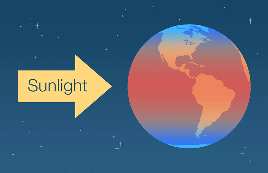
Uneven Heating
The energy from the Sun’s radiation is very strong — and relatively constant. Thankfully, Earth has a number of unique features that control how much of that energy is reflected back into space versus reaching the surface.
Earth’s Rotation
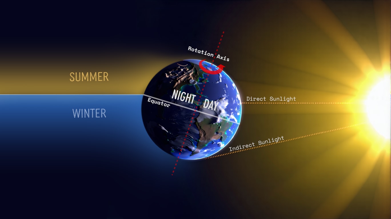
The Earth rotates on a tilted axis, completing a full rotation in “1 day” . This rotation creates days and nights — different areas of heating and cooling across the planet.
At any given time, approximately half of the Earth is receiving sunlight , while the other half is experiencing darkness .
Days and Nights acts like a temperature regulator
No part of Earth ever gets too hot.
Refer to the image below. Notice the tilted axis (red dashed line) and left (Night) vs. right (Day) sides of Earth.
Earth’s Orbit
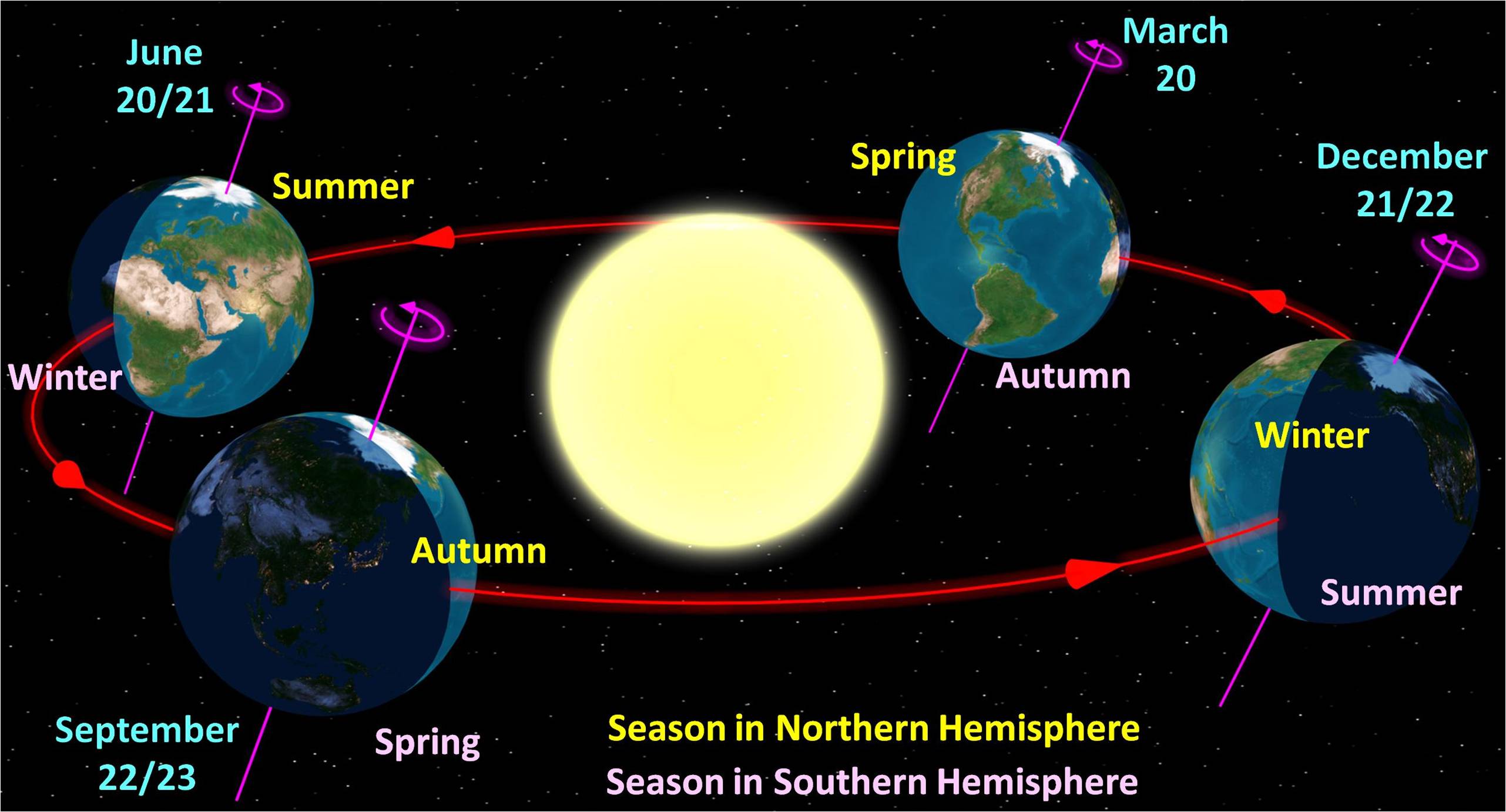
In addition to rotation on its own axis, Earth orbits on a path around the Sun, completing a full orbit in “1 year” .
Because of its tilt, some parts of Earth receive more direct (stronger) sunlight than other areas at different times of year — this is what creates our seasons.
Refer to the images above and below. Notice the tilt + orbit causes some parts of the Earth to be more directly heated.
Absorption
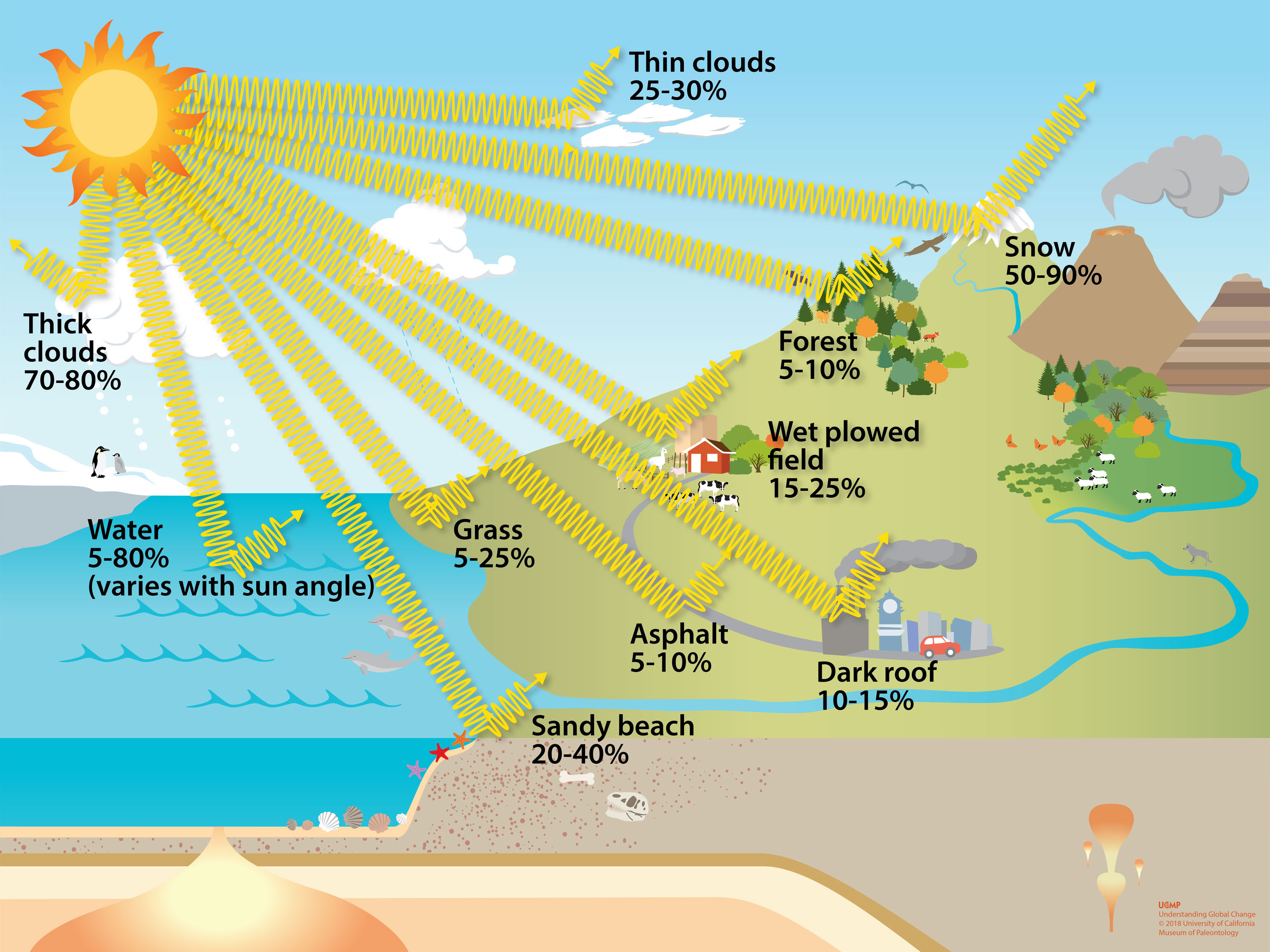
Different types of materials handle the Sun’s radiation differently. Some of the Sun’s energy is immediately reflected back to outer space. The remaining radition is absorbed by that material, causing it to heat up.
Only (approx.) 70% of the Sun’s energy reaches the Earth’s surface
Measuring Temperature
Most of us are familiar with measuring air temperature using a thermometer. But, there are actually multiple types temperature calculations that are used for understanding weather.
Some examples, just to name a few:
- Ambient/Air : basic air temperature we are most familiar with; taken in the shade
- Dew Point : temperature which water vapor begins to condense into liquid
- Web Bulb : thermometer covered with wet cloth exposed to moving air
- Apparent : feels like temperature accounting for heat index or wind chill
- Potential : air temperature adjusted at sea level pressure
Heat’s Role in Weather
Every gust of wind you’ve ever felt, every cloud you’ve watched drift across the sky, every raindrop that hits your face — exists because the Sun heats our planet unevenly .
The temperature of air plays a critical role in things like the amount of moisture the air can hold, the density or air pressure , and if wind is formed — all topics we’ll be discussing below!
Heat isn’t just part of weather, heat makes the weather!
The sections on this page will highlight the other phyiscal processes that contribute to weather, but you’ll see…they all tie back to uneven heating .
MIXING AIR
rise and fall of airWith the help of Earth’s rotation, orbit, and different surface materials, the temperature of air is different west to east, north to south, and from surface to mountain top.
These air masses don’t just sit still; they are constantly moving and changing. The natural rising and falling of air is a primary vehicle for the mixing of air.
As children, we learn that warm air rises and cool air sinks . But, what exaclty causes this to happen?

Air Density
Density is the amount of stuff packed into a given space.
An important characteristic of air:
as temperature increases, air E X P A N D S .
As the same amount of air molecules spread out over a wider area, the result is air becomes less dense.
Many of us also learned in school that objects that are less dense than their surroundings will float . So…
Warm air becomes less dense …resulting in a potential for it to rise .
The opposite is also true…
Cool air becomes more dense …resulting in a potential for it to sink .
But if density simply controls the potential (or “buoyancy”),
where does the actual movement of air come from? — Gravity!
Parcel Theory
Our Gravity pulls things towards Earth’s surface and is the external force that makes air rise and fall. Gravity acts on all air equally, but since cooler/denser air has a greater potential to sink, gravity wins — air gets pulled down.
As the cooler air reaches the surface, it flow under the warmer/less dense air, which has the potential to rise, but now gets the force needed to make it move up.
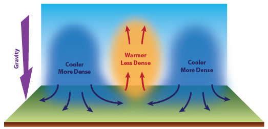
This process is known as Parcel Theory , and is the exact same process that causes a balloon with hot air to rise!
Air Circulation
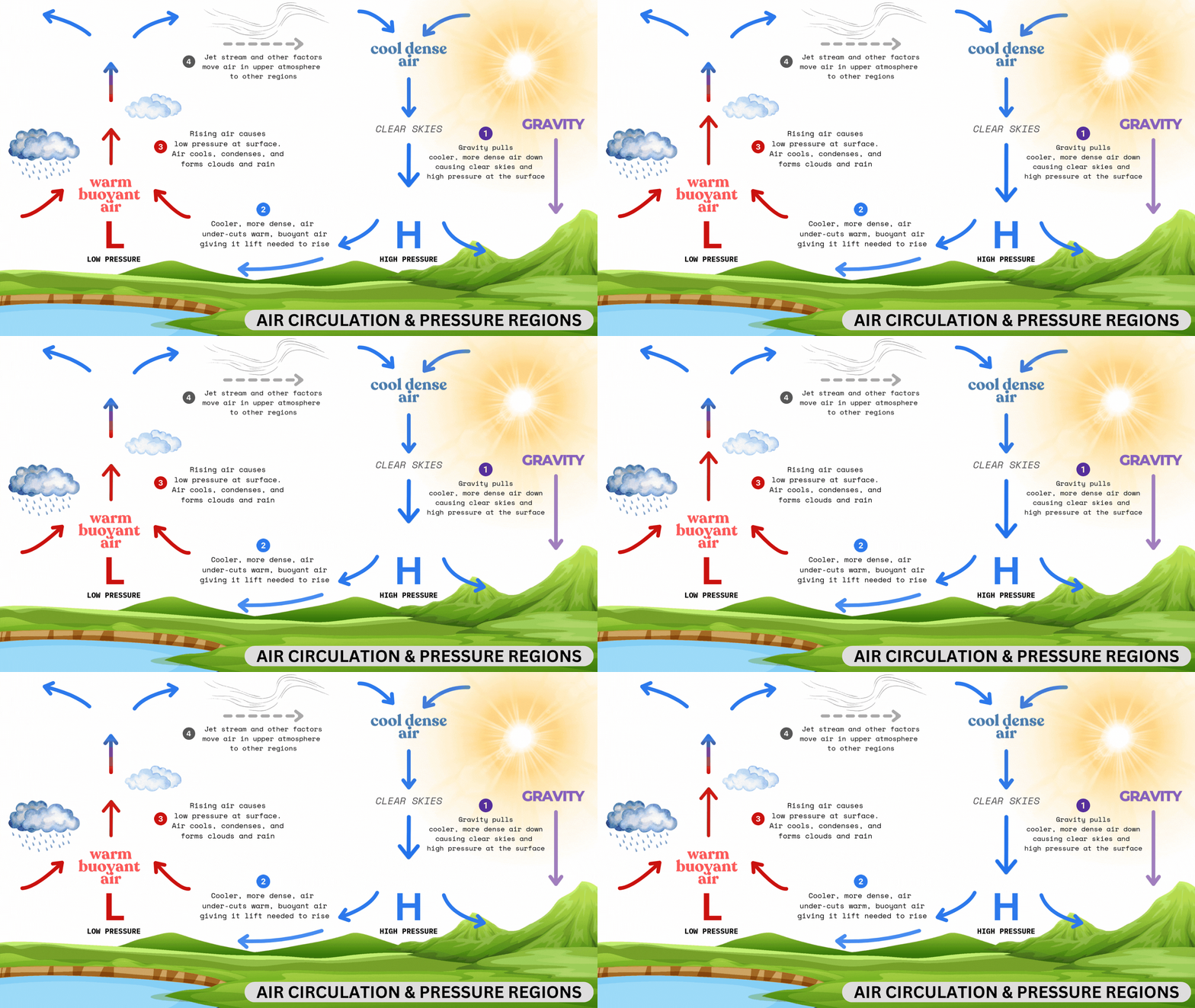
The cooler air, brought down to the surface, will push up and replace the buoyant warm air. But eventually, the cooler air will be heated by Earth’s surface materials (water, land, etc.) and begin to rise. Similarly, the warm, rising air will eventually reach upper levels of the atmosphere where it will begin cooling, becoming less dense and sinking back to the surface.
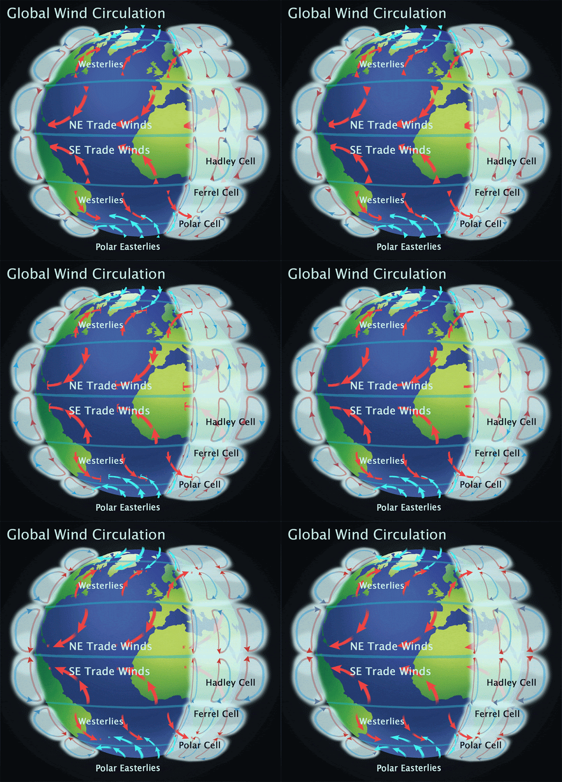
Large (global), persistent circulations of air are created through this process and are a topic discussed in greater detail in the article on Advanced Weather .
Air Transport
Large air masses are moved around Earth north, south, east, west too. There are a number of factors that cause this air to move around. Here are a few:
- Jet streams - created as result of air circulation ; super highways high in the atmosphere that move and steer air masses
- Ocean currents - like giant conveyor belts, move warm water around, which in turn heats up the air
- Air pressure - discussed more below, differences in air pressure creates wind… literally “the movement of air”
MOISTURE
Moisture is another fundamental component of our atmosphere and weather. There is a lot we could cover under this topic; we’ll explore some of the basics to support other basic topics on this page.
The amount of water on Earth and in our atmosphere is essentially fixed
No water goes away and no more is created — it just changes state.States include solid (ice), liquid (water), and gas (water vapor).
Air that has a lot of moisture (water vapor) in it is called: humid .
Measuring Humidity
Just like temperature, there are several ways we can measure the amount of moisture in the air — each telling us something different about it.
- Absolute Humidity - weight of water in a volume air (g/m3)
does NOT change with air temperature, but difficult for us to relate to - Relative Humidity - % of water, compared to maximum possible, at current temp
DOES change with air temperature - why it’s NOT a helpful measure of moisture - Dew Point - Temperature where water vapor converts back to liquid
does NOT change with air temperature - best overall indicator of moisture content
Water Cycle
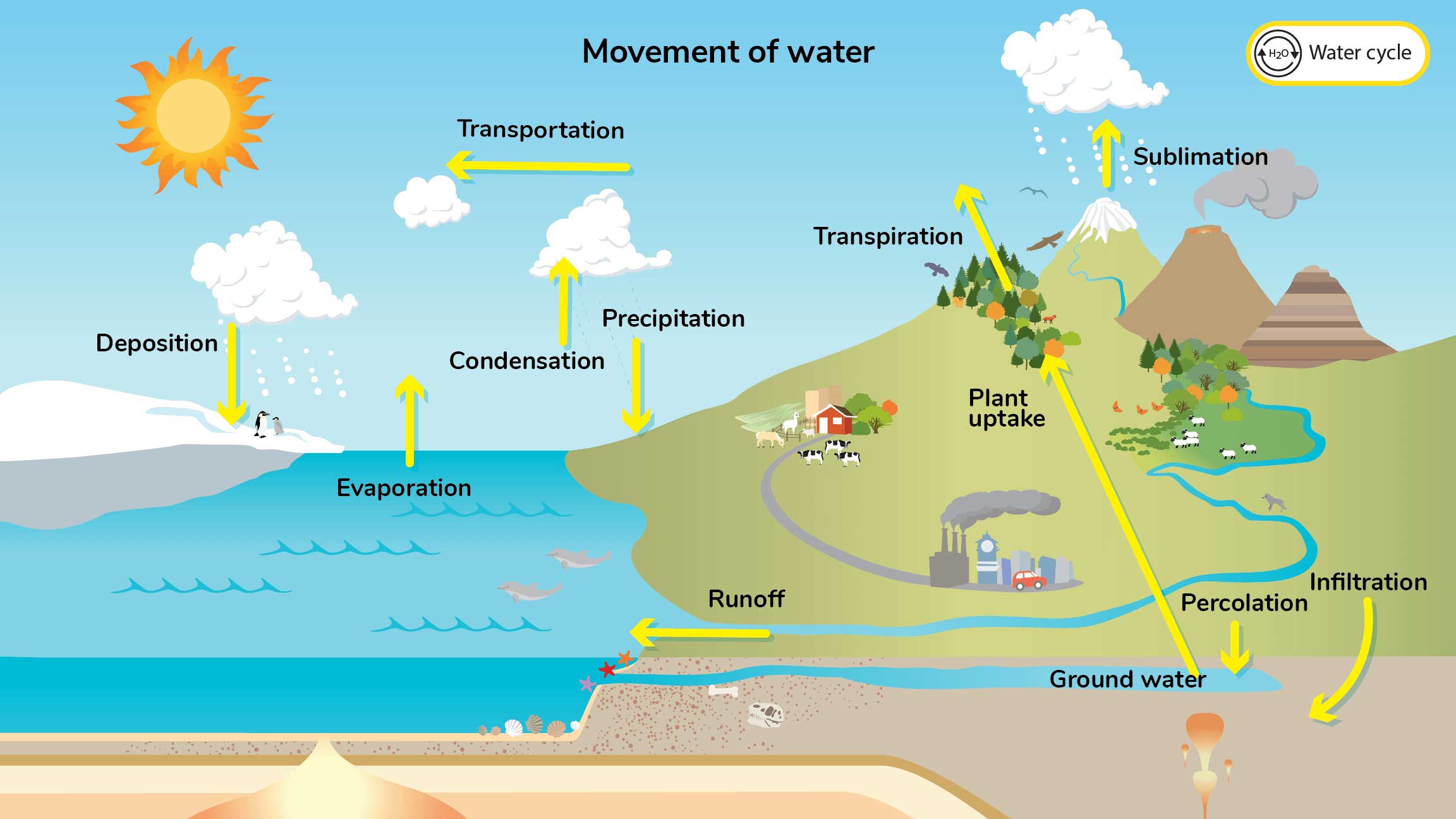
For the purposes of weather, the term “moisture” is primarily focused on water in its gas state, water vapor . How much moisture is present and how easily it can trasition between gas and liquid states plays a role in current and changing weather conditions.
The following image is a simplified illustration of Earth’s water cycle. We’ll reference this image in the following sections.
Evaporation
liquid -> gas (water vapor)There are several processes that convert water from liquid to gas, evaporation is one of the primary ways.
Evaporation occurs when energy from the sun heats water and molecules start moving faster. Some of the molecules moves so fast that they break from from the liquid at the surface and mix with air.
Condensation
water vapor (gas) -> liquidCondensation occurs when water vapor is cooled to a certain temperature and water vapor changes back to liquid state.
Precipitation
Precipitation follows condensation. As air cools, water vapor turns back into liquid form. Water molecules collect together and form clouds. When droplets become too heavy, they fall from the sky (i.e. rain).
We’ll discuss precipitation more in a dedicated section on Precipitation & Storms .
AIR PRESSURE
driving force of weatherAtmospheric pressure, also known as barometric pressure, is the weight of air pressing down on Earth.
Now that we understand Parcel Theory , air pressure should be easy to explain.

High Pressure
sea Level Pressure around 1015-1040mbAs gravity pulls cooler , less dense air molecules towards the center of Earth, this creates extra weight at the surface - creating High Pressure .
High pressure makes it difficult (or impossible) for air in that area to rise. If air cannot rise, condensation cannot occur and clouds are less likely to form in that area.
This is why high pressure systems are typically associated with clear skies.
Low Pressure
sea Level Pressure around 960-1010mbAs that cooler air comes to the surface in one area, it undercuts warmer , less dense air in other areas, causing it rise. This creates less air weight and thus Low Pressure .
Some of the rising air cools to it’s dew point where water vapor converts from gas to liquid form. Some of these water droplets collect together and the result is clouds . This is why low pressure systems are typically associated with rain/storms.
Pressure Differences
There are a number of ways that air pressure can be modified.
- Temperature - as air temperature changes, so does its density
- Elevation - as altitude increases, less air is above pushing down; pressure decreases
- Moisture - water vapor is less dense than dry air; humid areas have lower pressure
Pressure Balance
Air within high pressure area will move towards areas of low pressure, as the atmosphere is always trying to seek balance.
This movement of air is called Wind — which we’ll discuss more in the following section.
WIND
nature’s balancing actAs we just learned, Wind is the result of air moving from areas of high pressure towards areas of low pressure.
Nature is always trying to balance itself out.
Wind is how we feel that happening.
If two air masses have relatively similar air pressure, minimal wind will exist. However, two air masses with a large pressure difference will generate very strong wind.
In some parts of Earth, air masses of different air pressures exist in a fairly consistent manner throughout the year. This results in fairly consistent wind in those areas too.
Global Winds
Global winds are persistent winds that occur over large areas of Earth.
Surface Global Winds
These winds exist near the surface and typically range between 10-25mph.
- Trade Winds
- Westerlies / Polar Easterlies
Elevated Global Winds
These winds exist much further up in the atmosphere, near the top of the atmosphere, and reach much faster speeds: avg. 100-250 mph.
- Jet streams
- Polar Vortex
Many of these global winds are discussed in greater detail in Advanced Weather and ENSO .
Regional Winds
Consistent wind patterns can exist in regional locations too. These winds are typically found near major water/land features such as coastlines and mountain ranges.
Examples of Regional Winds
- Sea breezes
- Mountain/Valley breezes
- Monsoons
Local/Daily Winds
These are the winds that we feel day to day. They are the result of local temperature and pressure changes, terrain features, and surface conditions.
These winds change the most frequently (day to day), but they can still pack a big punch.
Surface winds typically range from 0-20mph, but can reach 60mph — or greater when associated with hurricane/thunderstorm activity.
FRONTS & BOUNDARIES
where air intersects and weather events occurA front is the “boundary line” between two air masses with different characteristics, such as temperature or humidity. Fronts create an area where changes in weather are more pronounced.
Fronts play an important role in weather, serving as a primary indicator of incoming changes. Fronts aren’t just warning signals though. They directly influence local and regional weather, which can help weather forecasters make predictions about upcoming changes or potential severity.
There are several different types of fronts or “boundaries”. For this dicussion, we’ll primarily look at Cold Fronts and Warm Fronts .
Cold Fronts
A cold front is a boundary where a colder air mass replaces a warmer.
Cold air charges forward lifting the warmer air ahead of it up.
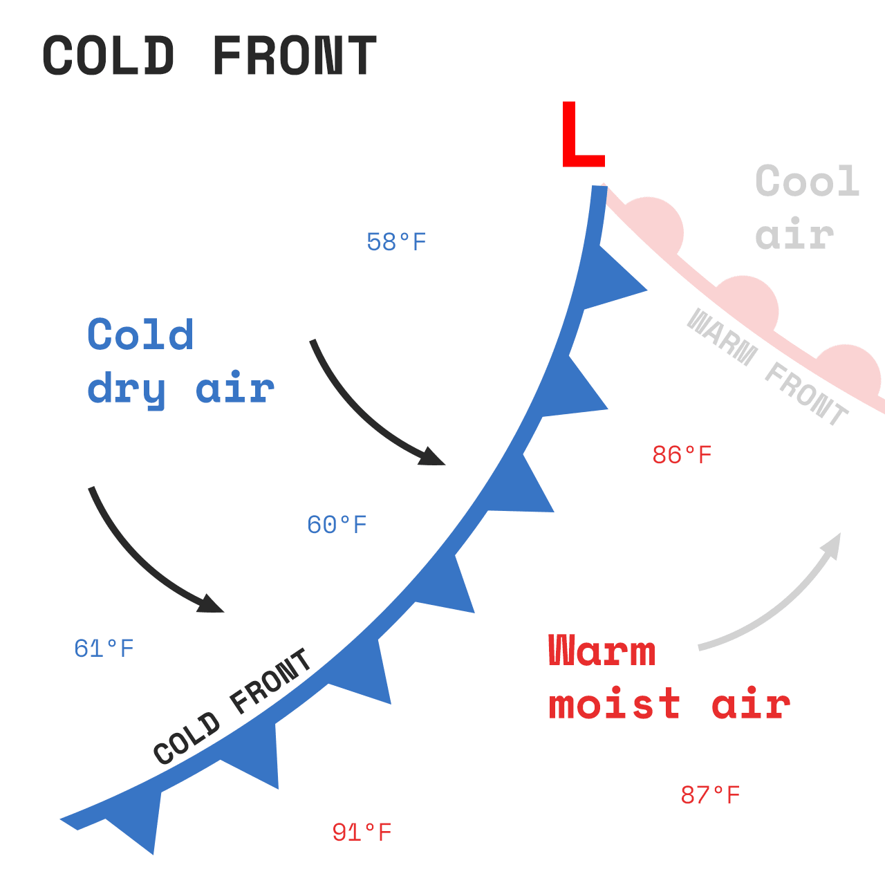
Think of a cold front as a heavy wedge at the surface,
lifting the lighter, warmer air ahead of it up
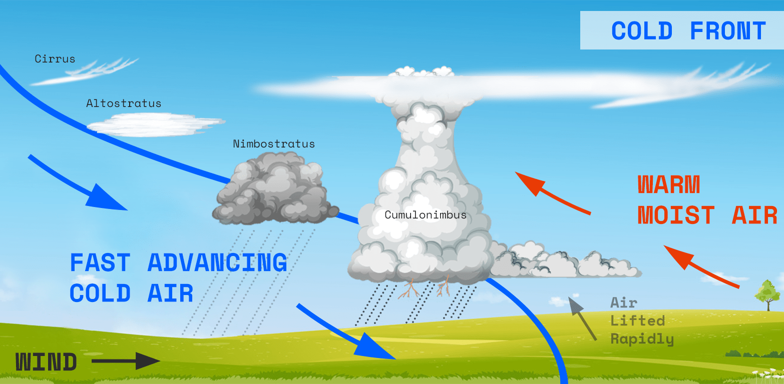
Characteristic
- Speed: often fast moving
- Temp: drops dramatically after a cold front
- Clouds: often preceded by a shelf cloud
- Precip: typically associated with quick rain showers and thunderstorms
- Sky: dramatically clear skies often follow
Warm Fronts
A warm front occurs when a warmer air mass replaces a colder one ahead of it.
Warm air moves slowly forward, sliding up and over the colder air ahead of it.
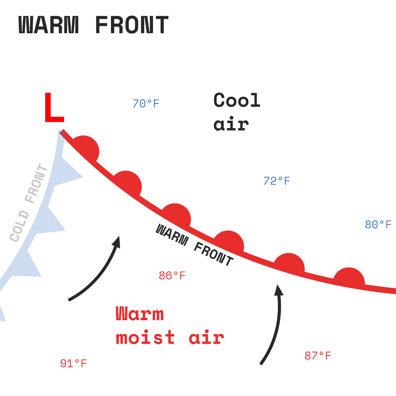
Think of a warm front as lighter air moving in,
which rides up a ramp of heavy/stubborn cold air ahead of it
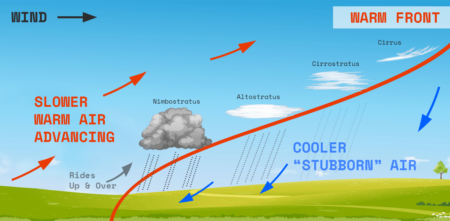
Characteristics
- Speed: typically much slower moving
- Temp: increases gradually after warm front
- Clouds: high, thin clouds precede the warm front, clouds transition towards the surface as the front approaches
- Precip: often associated with prolonged lighter rain/snow
- Sky: cloudy skies typically follow and clear slowly over days
Other Boundaries
- Stationary Front - similar to a warm front but very slow moving, hence the name
- Occluded Front - when a cold front moves faster and takes over a warm front
- Dry Line - boundary separating dry and moist air, influences severe storms
Precipitation & Storms
Precipitation is a fancy word for the moisture in air (water vapor) that grows too heavy for the air to support it and falls from the sky. Precipitation can have many forms, depending on the temperature of the air: rain, snow, sleet, etc.
As described in the section on moisture , precipitation is formed when humid air cools and condenses. Tiny water droplets collect together. This forms clouds. When enough water droplets collect and get too heavy, they fall.
Precipitation Types
Precipitation takes on different forms based on the temperature of the air. Rain is the most common type of precipitation, but
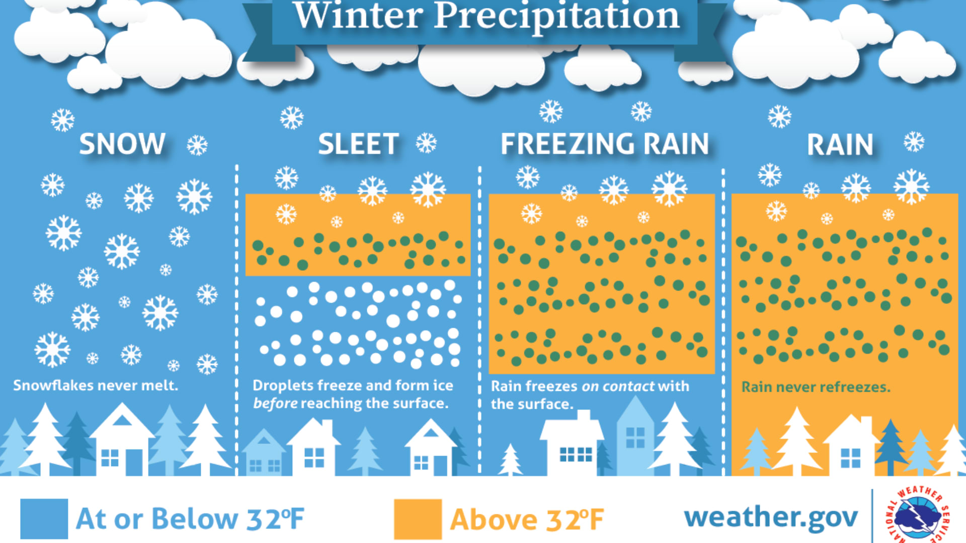
Winter Precipitation
As the temperature of air dip below freezing, other types of precipitation can form.
- Snow : forms when air is cold enough 32ºF/0ºC or below. Must maintain cold temperatures all the way to the ground
- Sleet : a mix of rain and snow, forms when rain falls through pockets of cold air
- Freezing Rain : Starts as snow, melts, and refreezes on surface contact.
Thunderstorms
When the ingredients and conditions in the atmosphere are just right, a simple rain shower can escalate into a severe thunderstorm.
Whether it’s a tropical storm in the Atlantic or a supercell in tornado alley, the basic concept of storm formation is the same.
- Basic thunderstorm formation
- Different types of precipitation
- Common storm patterns in the Midwest
Three main ingredients
- Moisture - moist air is less dense; it rises easier
- Unstable air - another way of saying the air is abnormally buoyant
- Lift - a forcing mechanism that can get things started - like a front
BONUS: Wind Shear - not required for thunderstorms, but required for sustained/severe thunderstorms
Summary
This page has explored several fundamental physical processes that work together to create our weather patterns.
Understanding these basic principles helps explain why weather behaves as it does, from the gentle morning fog in valleys to the dramatic formation of thunderstorms.
Here is a quick summary of the topics we’ve discussed.
If you’re interested in a deeper dive into some of this content, be sure to check out the Related Content information below.